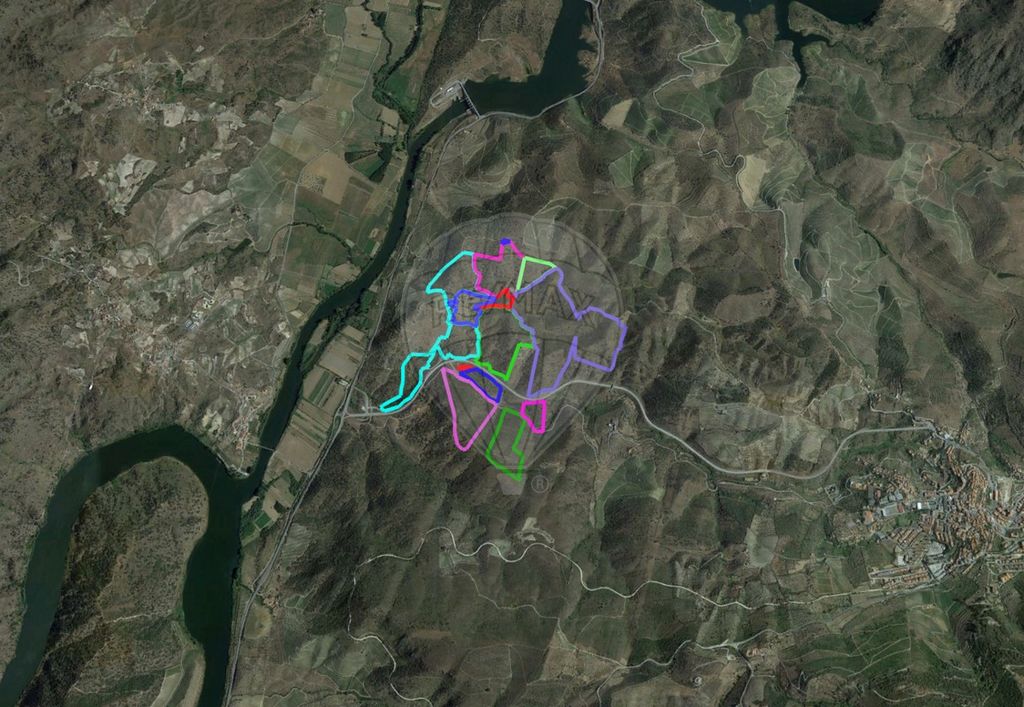
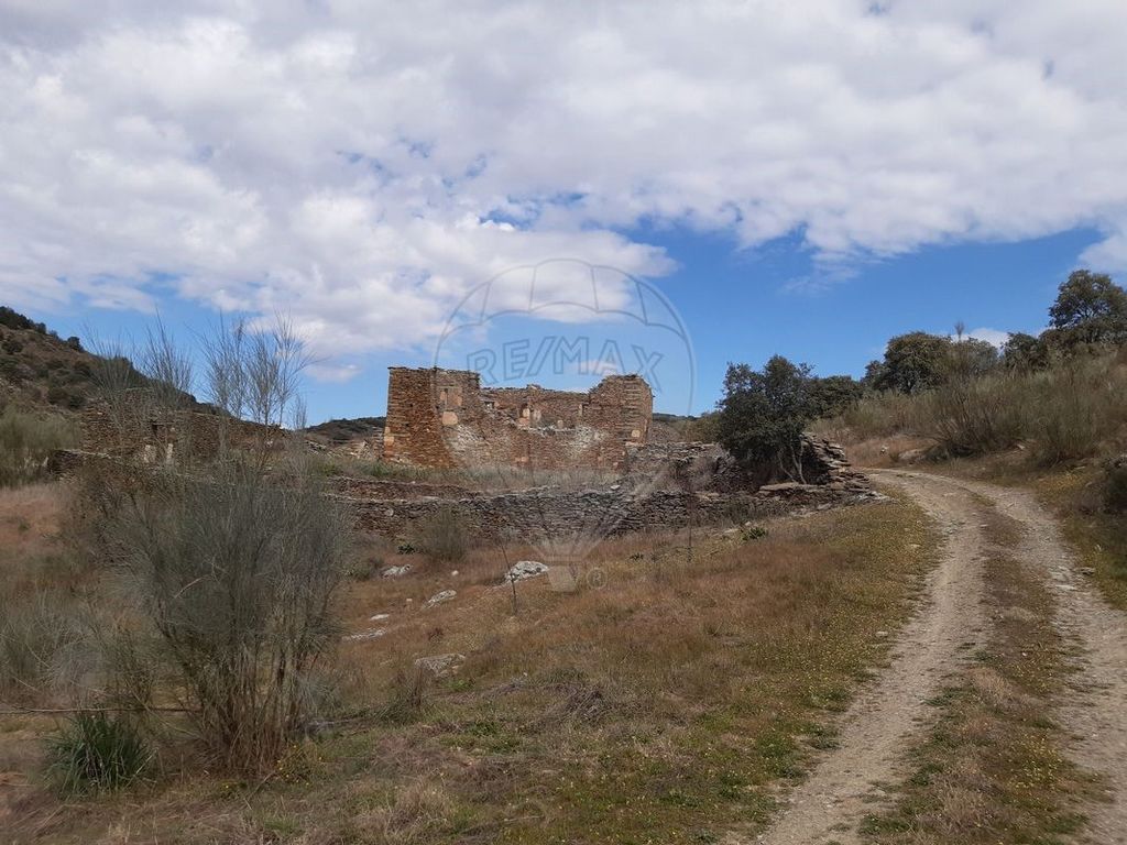
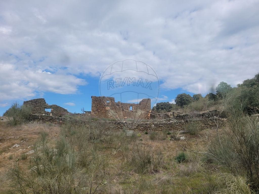
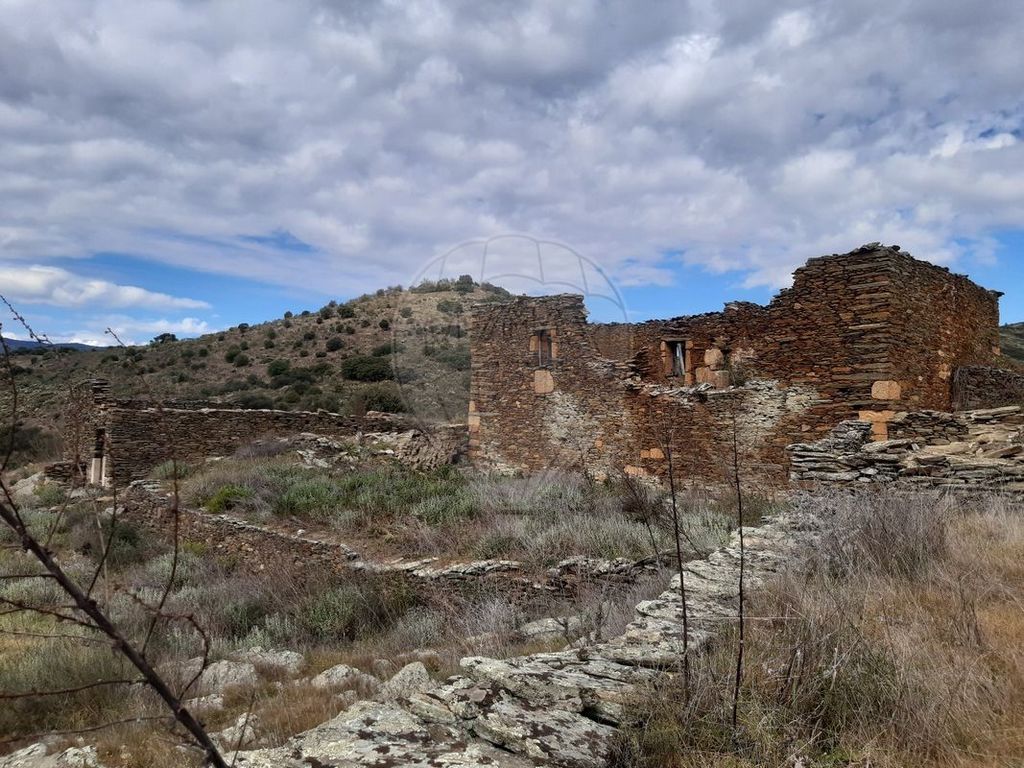
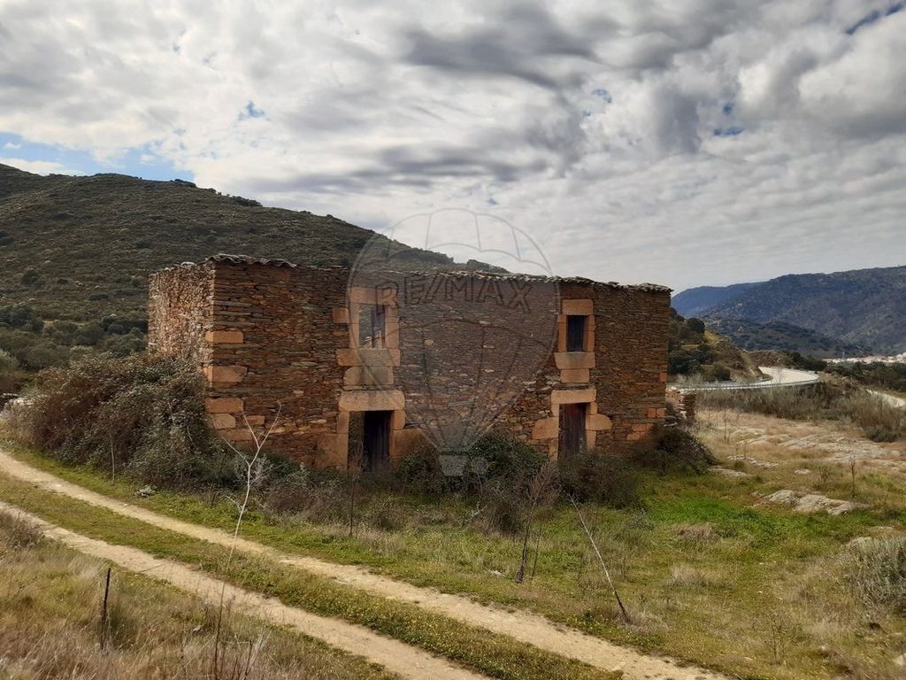
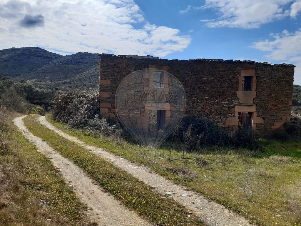
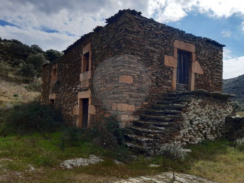
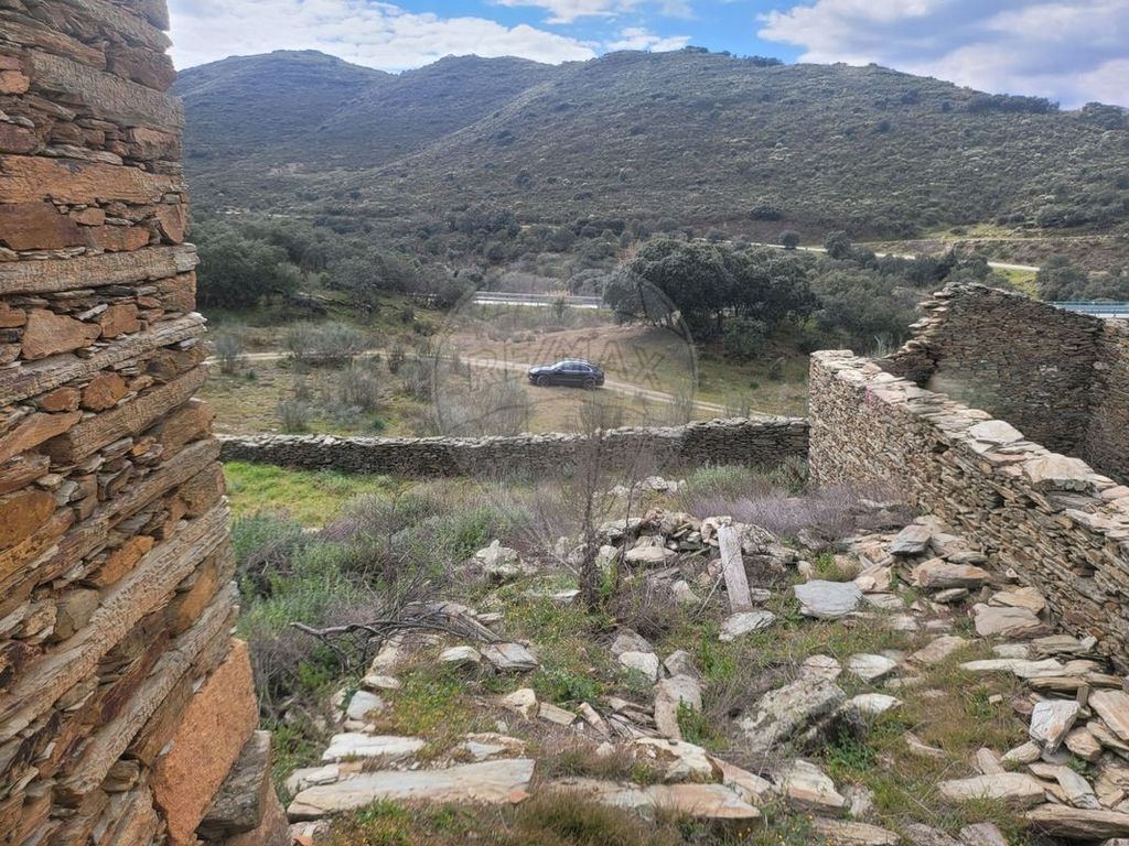
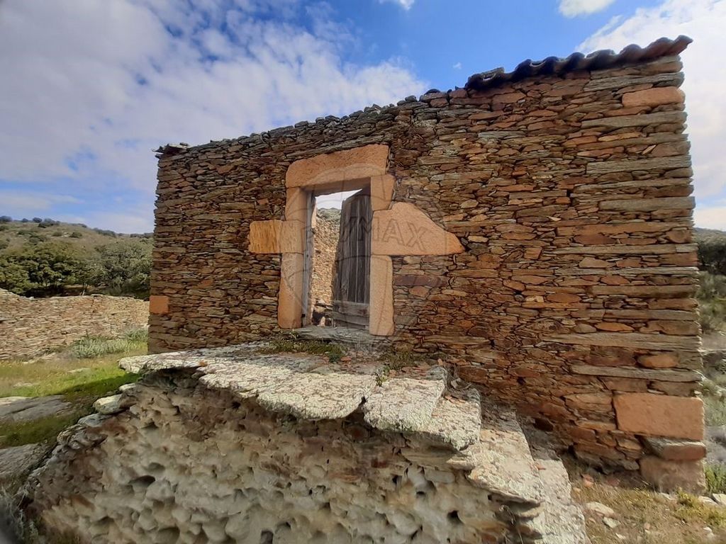
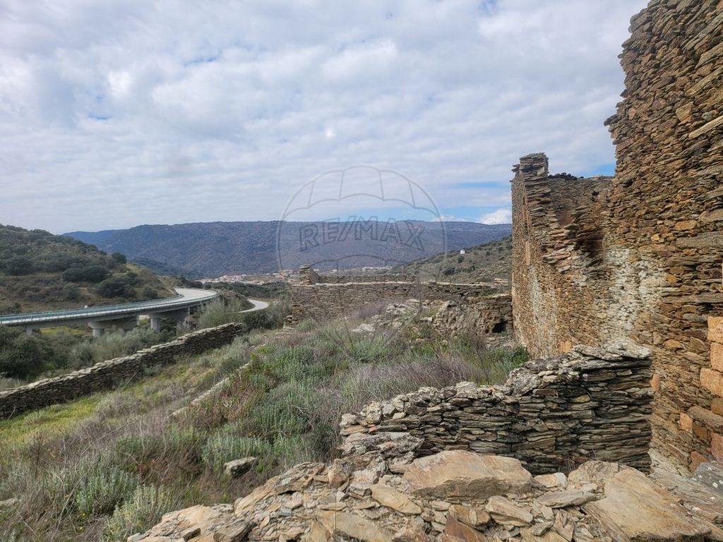
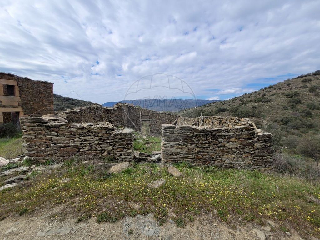
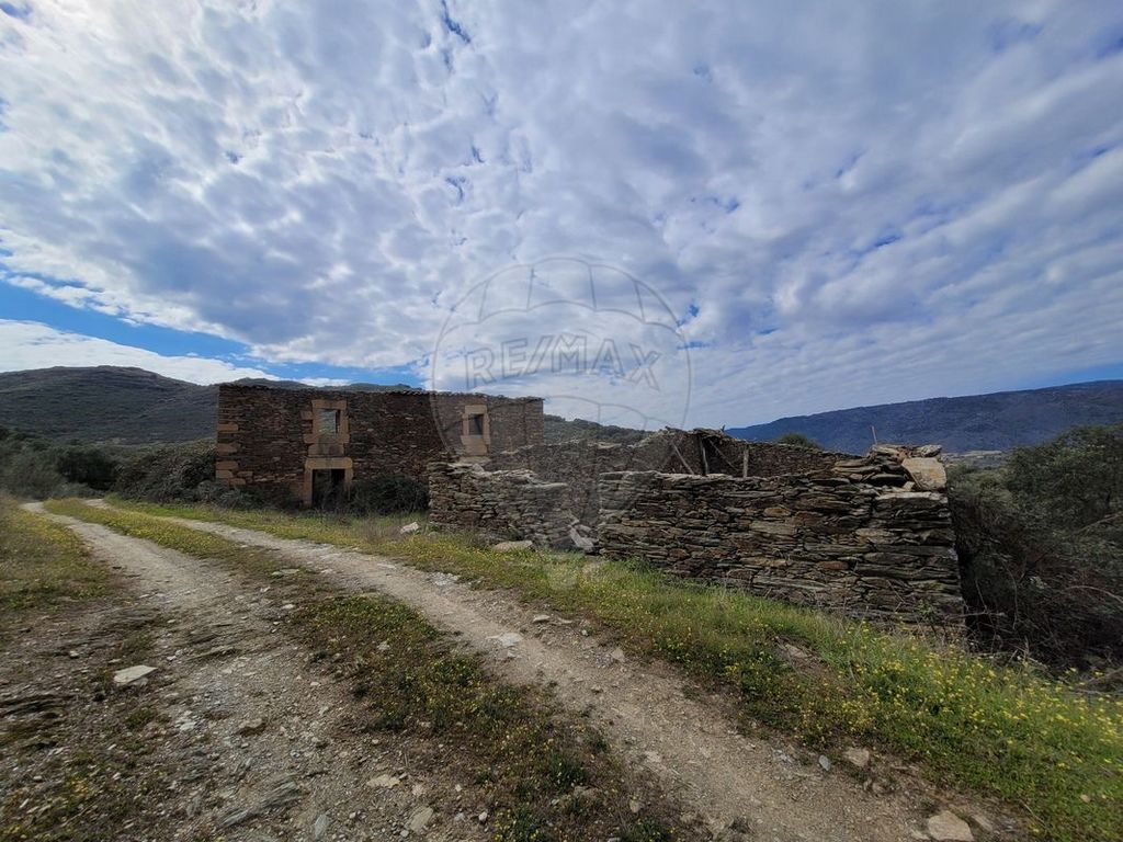
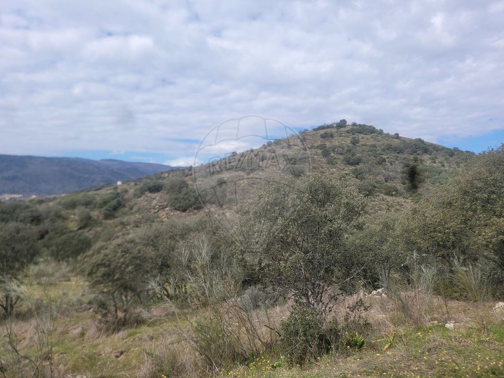
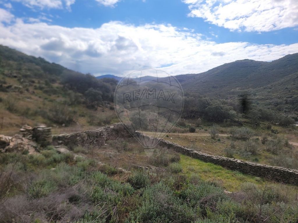
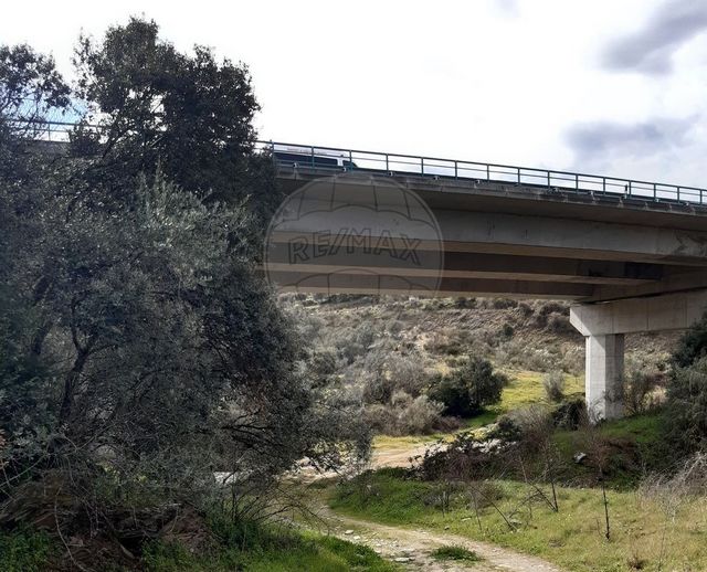
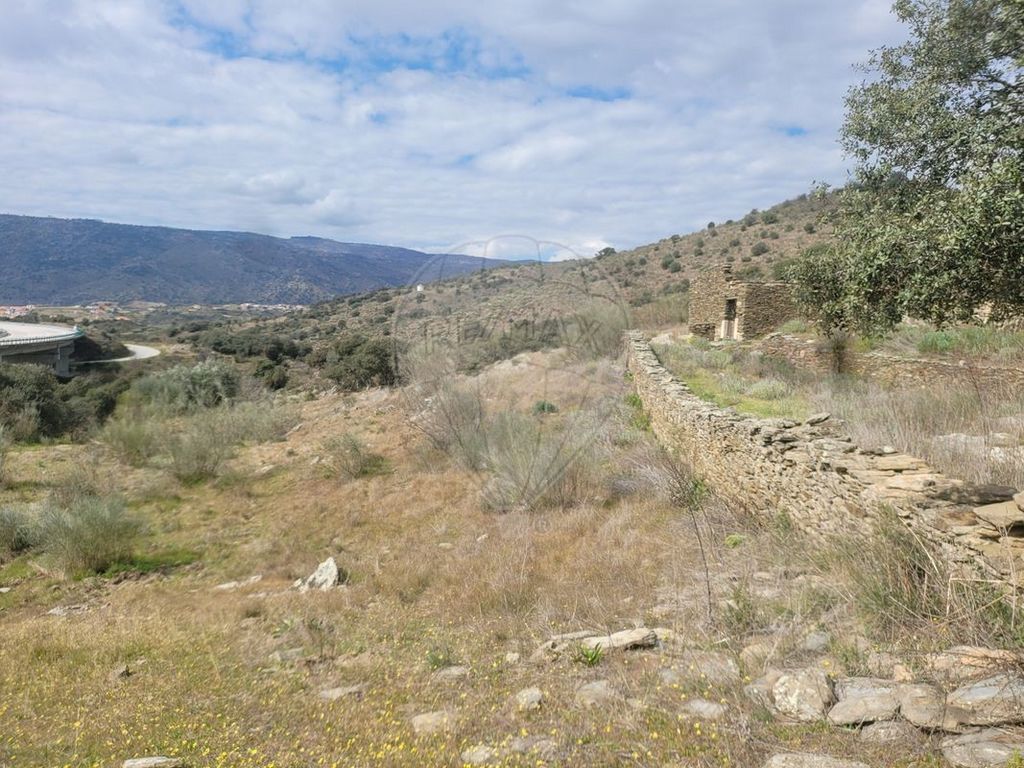
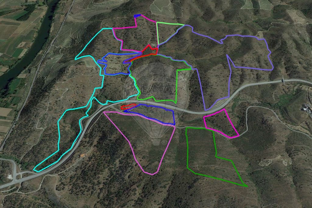
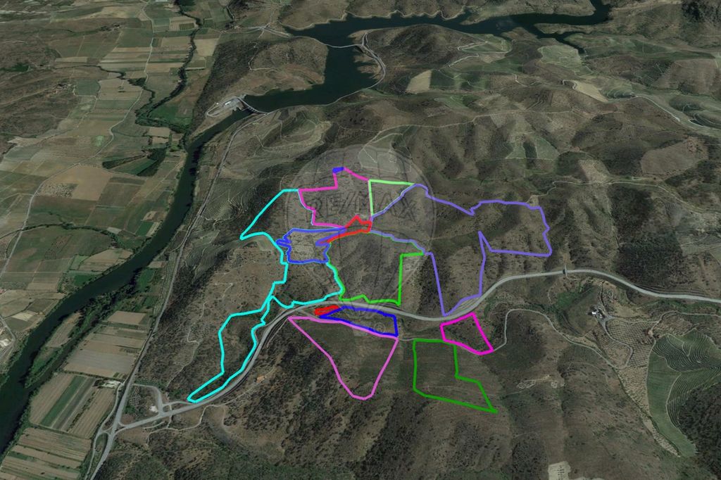
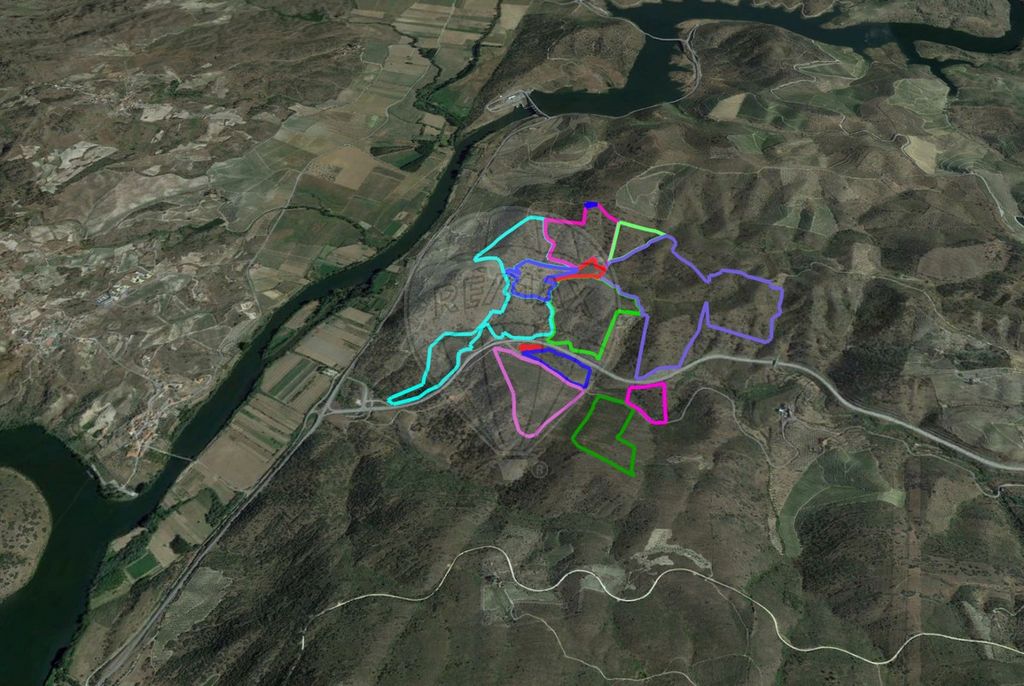
Property with 107.08ha (1,070,800m2) in Torre de Moncorvo, Bragança Main features: - rustic land; - 107.08ha (area of the resulting parcel) - Ruined shale buildings - Torre de Moncorvo is covered by the Demarcated Port Wine Region and the Alto Douro Wine Region, classified as a World Heritage Site by Unesco Points of interest: - 2.0km from the Sabor River - 2.5km from the river beach Foz do Rio Sabor - 3.6km from the Water Park - a 4.0km from Torre de Moncorvo centre - 4.9km from the Castle - 4.6km from Dr. Ramiro Salgado secondary school - 4.8km from Câmara Municipa - 13.8km from Vila Nova de Foz Côa Transport and access: - on the N220 - 900m from the N102/IP2 - 7.9km from the train (Station – Pocinho) - 47.0km from the A4 Areas (according to Caderneta Predial): - Total area (ha): 72.876500ha (728.765m2) Other values: - IMI value: approx. 14,17€ (annual) Municipal Master Plan: This land is classified in the PDM of Torre de Moncorvo as a production forest area (in part), Municipal ecological structure (in part), Ecological corridor (in part), National ecological reserve (almost in totality) (...) SUBSECTION I Forest production areas Article 26 Definition and regime 1 — These areas comprise soils with forest scrub and groves and are predominantly intended for the production of wood, cork, biomass and fruit and seeds, as well as areas with the function of protecting the hydrographic network and protecting theagainst wind, water and flood erosion. 2 - In forest production areas, the buildability regime, without prejudice to the specific legislation in force, is restricted to the following cases: a) Works for the extension, alteration and conservation of pre-existing buildings, with the increase in the construction area not exceeding 50% of that existing at the date of the intervention or the resulting total construction area exceeding 200m2; b) Expansion, alteration and conservation works of pre-existing buildings, when intended for tourism in rural areas or residential tourism, with no increase in the construction area exceeding 50% of that existing on the date of the intervention; c) Construction works of facilities to support the management of these areas, integrated in the operating systems duly authorised by the supervisory entities, provided that the construction area does not exceed the application of a utilisation index of 0.01 in relation to the total area exploitation; d) In any of the situations referred to in the preceding paragraphs, the height of new buildings or the height resulting from the extension of existing buildings may not exceed 7 metres, except for that inherent to special technical installations for fire prevention, energy recovery and the use of forest resources. (...) Article 53 Municipal ecological structure 1 – The municipal ecological structure, identified in the Planning Plan, encompasses the areas that play a decisive role in environmental protection and enhancement and in ensuring the safeguarding of ecosystems and the intensification of biophysical processes, including the model forest of the Reboredo mountain range. 2 - In the areas covered by the municipal ecological structure, without prejudice to the general legislation applicable and current uses, regardless of the category of space to which it is superimposed, the installation of any activity that compromises air quality is prohibited, of water, soil and landscape, namely deposits of solid waste, scrap, aggregates and materials of any nature or the discharge of effluents without adequate prior treatment in accordance with the regulations in force. 3 – The constraints on the use and transformation of the land to be required for the areas included in the municipal ecological structure are those established in the discipline of the categories of spaces that comprise it, articulated with the legal regimes applicable to the same areas. 4 - The minimum area of the plot required for construction works established in the specific regime of each category of space is doubled when superimposed on the municipal ecological structure. (...) Article 54 Ecological corridor 1 – The ecological corridor delimited in the Planning Plan is the one defined in the Douro PROF and referred to as, Montesinho/Sabor/Douro/ Douro Internacional and refers to the section that crosses the territory of Torre de Moncorvo, adjusted to the scale of the PDM. 2 - On rural land integrated in the defined ecological corridor, the provisions established in the previous article, referring to the municipal ecological structure, shall apply. 3 – Actions, works and activities permitted in the categories of spaces included in the ecological corridor shall only be licensed provided that they do not cause their interruption or significant reduction that would undermine the objectives underlying their delimitation, namely that of connecting populations of fauna and flora communities. 4 - Within the scope of forest planning, the standards to be applied within the ecological corridor are those considered for protection and conservation functions, in accordance with the provisions of the Douro PROF. (...) In the REN areas included in the Douro Demarcated Region, without prejudice to the provisions of the REN regime, the following provisions apply: (a) earthworks and destruction of vegetation cover shall not result in the obstruction or destruction of natural drainage lines or in the alteration of the morphology of the banks of watercourses or their vegetation; (b) Planting on slopes with a slope of more than 50 % shall be prohibited, except when the parcel of destination is occupied by vineyards or other permanent crops, or by mortories, in which case it may be carried out on micro-terraces; (c) planting on slopes with a slope of between 40 % and 50 % may be planted on narrow levels of a line or micro-levels; d) The planting of vines "at the top" may only be carried out on slopes or plots with an initial slope of less than 40%, except when the soils are anthroposols, with greater susceptibility to erosion, namely those corresponding to the cartographic unit Tasdx 1.1 of the soil map of Trás-os-Montes, where the ceiling is 30%; e) Plantations in plots already occupied by vineyards, olive groves or almond groves reinforced with walls, or even by mortórios, must be done using narrow or micro-terraces, maintaining retaining walls, except in cases where the Regional Directorate of Agriculture and Fisheries of the North (DRAP-N) gives a favourable opinion to their removal; f) The destruction of vernacular heritage values (stone walls, vernacular buildings, stone sidewalks, mortories), as well as nuclei of arboreal vegetation, is prohibited, except in duly substantiated cases that deserve a favorable opinion from DRAP-N. (...) in Regulation of the Municipal Master Plan of Torre de Moncorvo, Diário da República, 2nd series – No. 153 – 8 August 2021. We are available to help you make dreams come true, whether you buy or sell your property. ____ - 107.08ha (area resulting from the Parcelário) - ruined shale buildings - Torre de Moncorvo is covered by the Demarcated Region of Port Wine and the Alto Douro Wine Region area, classified as a World Heritage Site by Unesco Points of interest: - 2.0 km from Rio Sabor - 2.5 km from the river beach Foz do Rio Sabor - 3.6km from the Water Park - 4.0km from the center of Torre de Moncorvo - 4.9km from the Castle - 4.6 km from the secondary school Dr. Ramiro Salgado - 4.8km from City Hall - 13.8km from Vila Nova de Foz Côa Transport and access - on the N220 - 900m from N102/IP2 - 7.9km from the train (Station – Pocinho) - 47.0km from the A4 Areas (according to Building Book): - Total area (ha): 72.876500ha (728,765m2) Other values: - IMI value: approx. €14.17 (annual) ;ID RE/MAX: ...
Visa flerVisa färre
Descrição do imóvel Propriedade com 107,08ha (1.070.800m2) em Torre de Moncorvo, Bragança Principais características: - terreno rústico; - 107,08ha (área do resultante do Parcelário) - edificações de xisto em ruína - Torre de Moncorvo é abrangida pela Região Demarcada do Vinho do Porto e pela área do Alto Douro Vinhateiro, classificada como Património da Humanidade pela Unesco Pontos de interesse: - a 2,0km do Rio Sabor - a 2,5km da praia fluvial foz do rio sabor - a 3,6km do Parque Aquático - a 4,0km do centro de Torre de Moncorvo - a 4,9km do Castelo - a 4,6km da escola secundária Dr. Ramiro Salgado - a 4,8km da Câmara Municipa - a 13,8km de Vila Nova de Foz Côa Transportes e acessos: - na N220 - a 900m da N102/IP2 - a 7,9km do comboio (Estação – Pocinho) - a 47,0km da A4 Áreas (conforme Caderneta Predial): - Área total (ha): 72,876500ha (728.765m2) Outros valores: - valor de IMI: aprox. 14,17€ (anual) Plano Director Municipal : Este terreno está classificado no PDM de Torre de Moncorvo como Espaço florestal de produção (em parte), Estrutura ecológica municipal (totalidade), Corredor ecológico (em parte), Reserva ecológica nacional (quase na totalidade) (...) SUBSECÇÃO I Espaços florestais de produção Artigo 26.º Definição e regime 1 — Estes espaços compreendem os solos com matos e arvoredos florestais destinando-se predominantemente à produção de madeira, cortiça, biomassa e de frutos e sementes, bem como áreas com função de proteção da rede hidrográfica e de proteção contra a erosão eólica, hídrica e de cheias. 2 — Nos espaços florestais de produção o regime de edificabilidade, sem prejuízo da legislação específica em vigor, restringe-se aos seguintes casos: a) Obras de ampliação, de alteração e de conservação de edifícios pré-existentes, não podendo o acréscimo da área de construção ser superior a 50 % da existente à data da intervenção nem a área de construção total resultante ser superior a 200m2; b) Obras de ampliação, de alteração e de conservação de edifícios pré-existentes, quando destinados a empreendimentos de turismo no espaço rural ou de turismo de habitação, não podendo o acréscimo da área de construção ser superior a 50 % da existente à data da intervenção; c) Obras de construção de instalações de apoio à gestão destas áreas, integradas nos sistemas de exploração devidamente autorizados pelas entidades de tutela, desde que a área de construção não seja superior à aplicação de um índice de utilização de 0.01 em relação à área total de exploração; d) Em qualquer das situações referidas nos números anteriores, a cércea dos novos edifícios ou a resultante da ampliação de edifícios existentes não poderá ser superior a 7 metros, exceto a inerente a instalações técnicas especiais de prevenção a incêndios, de valorização energética e de aproveitamento de recursos florestais. (...) Artigo 53.º Estrutura ecológica municipal 1 — A estrutura ecológica municipal, identificada na Planta de Ordenamento, engloba as áreas que desempenham um papel determinante na proteção e valorização ambiental e na garantia da salvaguarda dos ecossistemas e da intensificação dos processos biofísicos incluindo a mata modelo da serra do Reboredo. 2 — Nas áreas abrangidas pela estrutura ecológica municipal, sem prejuízo da legislação geral aplicável e dos usos atuais, independentemente da categoria de espaço a que se sobrepõe, é interdita a instalação de qualquer atividade que comprometa a qualidade do ar, da água, do solo e da paisagem, nomeadamente depósitos de resíduos sólidos, sucatas, de inertes e de materiais de qualquer natureza ou o lançamento de efluentes sem tratamento prévio adequado de acordo com as normas em vigor. 3 — Os condicionamentos ao uso e transformação do solo a exigir para as áreas incluídas na estrutura ecológica municipal são os estabelecidos na disciplina das categorias de espaços que a integram, articulada com os regimes legais aplicáveis às mesmas áreas. 4 — A área mínima da parcela exigida para obras de construção estabelecida no regime especifico de cada categoria de espaço passa para o dobro quando sobreposta à estrutura ecológica municipal. (...) Artigo 54.º Corredor ecológico 1 — O corredor ecológico delimitado na Planta de Ordenamento é o definido no PROF Douro e designado por, Montesinho/Sabor/Douro/ Douro Internacional e respeita ao troço que cruza o território de Torre de Moncorvo, ajustado à escala do PDM. 2 — No solo rural integrado no corredor ecológico definido aplicam-se as disposições estabelecidas no artigo anterior, referente à estrutura ecológica municipal. 3 — As ações, obras e atividades admitidas nas categorias de espaços incluídas no corredor ecológico apenas são licenciadas desde que não provoquem a sua interrupção ou redução significativa que prejudique os objetivos subjacentes à sua delimitação, nomeadamente o de conectar populações de comunidades da fauna e da flora. 4 — No âmbito do planeamento florestal as normas a aplicar no interior do corredor ecológico são as consideradas para as funções de proteção e de conservação, de acordo com o estabelecido no PROF Douro. (...) Reserva ecológica nacional Nas áreas de REN incluídas na Região Demarcada do Douro, sem prejuízo do estabelecido no regime da REN, aplicam-se as seguintes disposições: a) As movimentações de terras e destruição do coberto vegetal não podem implicar a obstrução ou destruição das linhas de drenagem natural nem a alteração da morfologia das margens dos cursos de água, bem como da sua vegetação; b) As plantações em encostas com declive superior a 50 % são interditas, salvo quando a parcela de destino estiver ocupada por vinha ou outra cultura permanente, ou ainda por mortórios, caso em que pode ser efetuada em micropatamares; c) As plantações em encostas com declive compreendido entre 40 % e 50 % podem ser efetuadas em patamares estreitos de uma linha ou micropatamares; d) A plantação da vinha “ao alto” só pode ser efetuada em encostas ou parcelas com declive inicial da encosta inferior a 40 %, exceto quando os solos sejam antrosolos, com maior suscetibilidade à erosão, nomeadamente os correspondentes à unidade cartográfica Tasdx 1.1 da carta de solos de Trás-os-Montes, onde o limite máximo é de 30 %; e) As plantações em parcelas já ocupadas por vinha, olival ou amendoal armadas com muros, ou ainda por mortórios, tem de ser feita com recurso a patamares estreitos ou micropatamares, mantendo muros de suporte, salvo nos casos em que a Direção Regional de Agricultura e Pescas do Norte (DRAP—N) dê parecer favorável à sua remoção; f) É interdita a destruição de valores patrimoniais vernáculos (muros de pedra, edifícios vernáculos, calçadas de pedra, mortórios), bem como de núcleos de vegetação arbórea, salvo nos casos devidamente fundamentados que mereçam parecer favorável da DRAP-N. (...) in Regulamento do Plano Director Municipal de Torre de Moncorvo, Diário da República, 2.ª série – N.º 153 – 8 de agosto de 2021. Estamos disponíveis para o ajudar a realizar sonhos, seja na compra ou na venda do seu imóvel. ___________________ Property Description Property with 107.08ha (1,070,800m2) in Torre de Moncorvo, Bragança Main features: -...
Property with 107.08ha (1,070,800m2) in Torre de Moncorvo, Bragança Main features: - rustic land; - 107.08ha (area of the resulting parcel) - Ruined shale buildings - Torre de Moncorvo is covered by the Demarcated Port Wine Region and the Alto Douro Wine Region, classified as a World Heritage Site by Unesco Points of interest: - 2.0km from the Sabor River - 2.5km from the river beach Foz do Rio Sabor - 3.6km from the Water Park - a 4.0km from Torre de Moncorvo centre - 4.9km from the Castle - 4.6km from Dr. Ramiro Salgado secondary school - 4.8km from Câmara Municipa - 13.8km from Vila Nova de Foz Côa Transport and access: - on the N220 - 900m from the N102/IP2 - 7.9km from the train (Station – Pocinho) - 47.0km from the A4 Areas (according to Caderneta Predial): - Total area (ha): 72.876500ha (728.765m2) Other values: - IMI value: approx. 14,17€ (annual) Municipal Master Plan: This land is classified in the PDM of Torre de Moncorvo as a production forest area (in part), Municipal ecological structure (in part), Ecological corridor (in part), National ecological reserve (almost in totality) (...) SUBSECTION I Forest production areas Article 26 Definition and regime 1 — These areas comprise soils with forest scrub and groves and are predominantly intended for the production of wood, cork, biomass and fruit and seeds, as well as areas with the function of protecting the hydrographic network and protecting theagainst wind, water and flood erosion. 2 - In forest production areas, the buildability regime, without prejudice to the specific legislation in force, is restricted to the following cases: a) Works for the extension, alteration and conservation of pre-existing buildings, with the increase in the construction area not exceeding 50% of that existing at the date of the intervention or the resulting total construction area exceeding 200m2; b) Expansion, alteration and conservation works of pre-existing buildings, when intended for tourism in rural areas or residential tourism, with no increase in the construction area exceeding 50% of that existing on the date of the intervention; c) Construction works of facilities to support the management of these areas, integrated in the operating systems duly authorised by the supervisory entities, provided that the construction area does not exceed the application of a utilisation index of 0.01 in relation to the total area exploitation; d) In any of the situations referred to in the preceding paragraphs, the height of new buildings or the height resulting from the extension of existing buildings may not exceed 7 metres, except for that inherent to special technical installations for fire prevention, energy recovery and the use of forest resources. (...) Article 53 Municipal ecological structure 1 – The municipal ecological structure, identified in the Planning Plan, encompasses the areas that play a decisive role in environmental protection and enhancement and in ensuring the safeguarding of ecosystems and the intensification of biophysical processes, including the model forest of the Reboredo mountain range. 2 - In the areas covered by the municipal ecological structure, without prejudice to the general legislation applicable and current uses, regardless of the category of space to which it is superimposed, the installation of any activity that compromises air quality is prohibited, of water, soil and landscape, namely deposits of solid waste, scrap, aggregates and materials of any nature or the discharge of effluents without adequate prior treatment in accordance with the regulations in force. 3 – The constraints on the use and transformation of the land to be required for the areas included in the municipal ecological structure are those established in the discipline of the categories of spaces that comprise it, articulated with the legal regimes applicable to the same areas. 4 - The minimum area of the plot required for construction works established in the specific regime of each category of space is doubled when superimposed on the municipal ecological structure. (...) Article 54 Ecological corridor 1 – The ecological corridor delimited in the Planning Plan is the one defined in the Douro PROF and referred to as, Montesinho/Sabor/Douro/ Douro Internacional and refers to the section that crosses the territory of Torre de Moncorvo, adjusted to the scale of the PDM. 2 - On rural land integrated in the defined ecological corridor, the provisions established in the previous article, referring to the municipal ecological structure, shall apply. 3 – Actions, works and activities permitted in the categories of spaces included in the ecological corridor shall only be licensed provided that they do not cause their interruption or significant reduction that would undermine the objectives underlying their delimitation, namely that of connecting populations of fauna and flora communities. 4 - Within the scope of forest planning, the standards to be applied within the ecological corridor are those considered for protection and conservation functions, in accordance with the provisions of the Douro PROF. (...) In the REN areas included in the Douro Demarcated Region, without prejudice to the provisions of the REN regime, the following provisions apply: (a) earthworks and destruction of vegetation cover shall not result in the obstruction or destruction of natural drainage lines or in the alteration of the morphology of the banks of watercourses or their vegetation; (b) Planting on slopes with a slope of more than 50 % shall be prohibited, except when the parcel of destination is occupied by vineyards or other permanent crops, or by mortories, in which case it may be carried out on micro-terraces; (c) planting on slopes with a slope of between 40 % and 50 % may be planted on narrow levels of a line or micro-levels; d) The planting of vines "at the top" may only be carried out on slopes or plots with an initial slope of less than 40%, except when the soils are anthroposols, with greater susceptibility to erosion, namely those corresponding to the cartographic unit Tasdx 1.1 of the soil map of Trás-os-Montes, where the ceiling is 30%; e) Plantations in plots already occupied by vineyards, olive groves or almond groves reinforced with walls, or even by mortórios, must be done using narrow or micro-terraces, maintaining retaining walls, except in cases where the Regional Directorate of Agriculture and Fisheries of the North (DRAP-N) gives a favourable opinion to their removal; f) The destruction of vernacular heritage values (stone walls, vernacular buildings, stone sidewalks, mortories), as well as nuclei of arboreal vegetation, is prohibited, except in duly substantiated cases that deserve a favorable opinion from DRAP-N. (...) in Regulation of the Municipal Master Plan of Torre de Moncorvo, Diário da República, 2nd series – No. 153 – 8 August 2021. We are available to help you make dreams come true, whether you buy or sell your property. ____ - 107.08ha (area resulting from the Parcelário) - ruined shale buildings - Torre de Moncorvo is covered by the Demarcated Region of Port Wine and the Alto Douro Wine Region area, classified as a World Heritage Site by Unesco Points of interest: - 2.0 km from Rio Sabor - 2.5 km from the river beach Foz do Rio Sabor - 3.6km from the Water Park - 4.0km from the center of Torre de Moncorvo - 4.9km from the Castle - 4.6 km from the secondary school Dr. Ramiro Salgado - 4.8km from City Hall - 13.8km from Vila Nova de Foz Côa Transport and access - on the N220 - 900m from N102/IP2 - 7.9km from the train (Station – Pocinho) - 47.0km from the A4 Areas (according to Building Book): - Total area (ha): 72.876500ha (728,765m2) Other values: - IMI value: approx. €14.17 (annual) ;ID RE/MAX: ...
- IMI value: approx. 14,17€ (annual) Municipal Master Plan: This land is classified in the PDM of Torre de Moncorvo as a production forest area (in part), Municipal ecological structure (in part), Ecological corridor (in part), National ecological reserve (almost in totality) (...) SUBSECTION I Forest production areas Article 26 Definition and regime 1 — These areas comprise soils with forest scrub and groves and are predominantly intended for the production of wood, cork, biomass and fruit and seeds, as well as areas with the function of protecting the hydrographic network and protecting theagainst wind, water and flood erosion. 2 - In forest production areas, the buildability regime, without prejudice to the specific legislation in force, is restricted to the following cases:
a) Works for the extension, alteration and conservation of pre-existing buildings, with the increase in the construction area not exceeding 50% of that existing at the date of the intervention or the resulting total construction area exceeding 200m2;
b) Expansion, alteration and conservation works of pre-existing buildings, when intended for tourism in rural areas or residential tourism, with no increase in the construction area exceeding 50% of that existing on the date of the intervention;
c) Construction works of facilities to support the management of these areas, integrated in the operating systems duly authorised by the supervisory entities, provided that the construction area does not exceed the application of a utilisation index of 0.01 in relation to the total area exploitation;
d) In any of the situations referred to in the preceding paragraphs, the height of new buildings or the height resulting from the extension of existing buildings may not exceed 7 metres, except for that inherent to special technical installations for fire prevention, energy recovery and the use of forest resources. (...) Article 53 Municipal ecological structure 1 – The municipal ecological structure, identified in the Planning Plan, encompasses the areas that play a decisive role in environmental protection and enhancement and in ensuring the safeguarding of ecosystems and the intensification of biophysical processes, including the model forest of the Reboredo mountain range. 2 - In the areas covered by the municipal ecological structure, without prejudice to the general legislation applicable and current uses, regardless of the category of space to which it is superimposed, the installation of any activity that compromises air quality is prohibited, of water, soil and landscape, namely deposits of solid waste, scrap, aggregates and materials of any nature or the discharge of effluents without adequate prior treatment in accordance with the regulations in force. 3 – The constraints on the use and transformation of the land to be required for the areas included in the municipal ecological structure are those established in the discipline of the categories of spaces that comprise it, articulated with the legal regimes applicable to the same areas. 4 - The minimum area of the plot required for construction works established in the specific regime of each category of space is doubled when superimposed on the municipal ecological structure. (...) Article 54 Ecological corridor 1 – The ecological corridor delimited in the Planning Plan is the one defined in the Douro PROF and referred to as, Montesinho/Sabor/Douro/ Douro Internacional and refers to the section that crosses the territory of Torre de Moncorvo, adjusted to the scale of the PDM. 2 - On rural land integrated in the defined ecological corridor, the provisions established in the previous article, referring to the municipal ecological structure, shall apply. 3 – Actions, works and activities permitted in the categories of spaces included in the ecological corridor shall only be licensed provided that they do not cause their interruption or significant reduction that would undermine the objectives underlying their delimitation, namely that of connecting populations of fauna and flora communities. 4 - Within the scope of forest planning, the standards to be applied within the ecological corridor are those considered for protection and conservation functions, in accordance with the provisions of the Douro PROF. (...) In the REN areas included in the Douro Demarcated Region, without prejudice to the provisions of the REN regime, the following provisions apply:
(a) earthworks and destruction of vegetation cover shall not result in the obstruction or destruction of natural drainage lines or in the alteration of the morphology of the banks of watercourses or their vegetation;
(b) Planting on slopes with a slope of more than 50 % shall be prohibited, except when the parcel of destination is occupied by vineyards or other permanent crops, or by mortories, in which case it may be carried out on micro-terraces;
(c) planting on slopes with a slope of between 40 % and 50 % may be planted on narrow levels of a line or micro-levels;
d) The planting of vines "at the top" may only be carried out on slopes or plots with an initial slope of less than 40%, except when the soils are anthroposols, with greater susceptibility to erosion, namely those corresponding to the cartographic unit Tasdx 1.1 of the soil map of Trás-os-Montes, where the ceiling is 30%;
e) Plantations in plots already occupied by vineyards, olive groves or almond groves reinforced with walls, or even by mortórios, must be done using narrow or micro-terraces, maintaining retaining walls, except in cases where the Regional Directorate of Agriculture and Fisheries of the North (DRAP-N) gives a favourable opinion to their removal;
f) The destruction of vernacular heritage values (stone walls, vernacular buildings, stone sidewalks, mortories), as well as nuclei of arboreal vegetation, is prohibited, except in duly substantiated cases that deserve a favorable opinion from DRAP-N. (...) in Regulation of the Municipal Master Plan of Torre de Moncorvo, Diário da República, 2nd series – No. 153 – 8 August 2021. We are available to help you make dreams come true, whether you buy or sell your property. ____ - 107.08ha (area resulting from the Parcelário) - ruined shale buildings - Torre de Moncorvo is covered by the Demarcated Region of Port Wine and the Alto Douro Wine Region area, classified as a World Heritage Site by Unesco Points of interest: - 2.0 km from Rio Sabor - 2.5 km from the river beach Foz do Rio Sabor - 3.6km from the Water Park - 4.0km from the center of Torre de Moncorvo - 4.9km from the Castle - 4.6 km from the secondary school Dr. Ramiro Salgado - 4.8km from City Hall - 13.8km from Vila Nova de Foz Côa Transport and access - on the N220 - 900m from N102/IP2 - 7.9km from the train (Station – Pocinho) - 47.0km from the A4 Areas (according to Building Book): - Total area (ha): 72.876500ha (728,765m2)
Other values: - IMI value: approx. €14.17 (annual) ;ID RE/MAX: ... Visa fler Visa färre Descrição do imóvel Propriedade com 107,08ha (1.070.800m2) em Torre de Moncorvo, Bragança Principais características: - terreno rústico; - 107,08ha (área do resultante do Parcelário) - edificações de xisto em ruína - Torre de Moncorvo é abrangida pela Região Demarcada do Vinho do Porto e pela área do Alto Douro Vinhateiro, classificada como Património da Humanidade pela Unesco Pontos de interesse: - a 2,0km do Rio Sabor - a 2,5km da praia fluvial foz do rio sabor - a 3,6km do Parque Aquático - a 4,0km do centro de Torre de Moncorvo - a 4,9km do Castelo - a 4,6km da escola secundária Dr. Ramiro Salgado - a 4,8km da Câmara Municipa - a 13,8km de Vila Nova de Foz Côa Transportes e acessos: - na N220 - a 900m da N102/IP2 - a 7,9km do comboio (Estação – Pocinho) - a 47,0km da A4 Áreas (conforme Caderneta Predial): - Área total (ha): 72,876500ha (728.765m2) Outros valores: - valor de IMI: aprox. 14,17€ (anual) Plano Director Municipal : Este terreno está classificado no PDM de Torre de Moncorvo como Espaço florestal de produção (em parte), Estrutura ecológica municipal (totalidade), Corredor ecológico (em parte), Reserva ecológica nacional (quase na totalidade) (...) SUBSECÇÃO I Espaços florestais de produção Artigo 26.º Definição e regime 1 — Estes espaços compreendem os solos com matos e arvoredos florestais destinando-se predominantemente à produção de madeira, cortiça, biomassa e de frutos e sementes, bem como áreas com função de proteção da rede hidrográfica e de proteção contra a erosão eólica, hídrica e de cheias. 2 — Nos espaços florestais de produção o regime de edificabilidade, sem prejuízo da legislação específica em vigor, restringe-se aos seguintes casos: a) Obras de ampliação, de alteração e de conservação de edifícios pré-existentes, não podendo o acréscimo da área de construção ser superior a 50 % da existente à data da intervenção nem a área de construção total resultante ser superior a 200m2; b) Obras de ampliação, de alteração e de conservação de edifícios pré-existentes, quando destinados a empreendimentos de turismo no espaço rural ou de turismo de habitação, não podendo o acréscimo da área de construção ser superior a 50 % da existente à data da intervenção; c) Obras de construção de instalações de apoio à gestão destas áreas, integradas nos sistemas de exploração devidamente autorizados pelas entidades de tutela, desde que a área de construção não seja superior à aplicação de um índice de utilização de 0.01 em relação à área total de exploração; d) Em qualquer das situações referidas nos números anteriores, a cércea dos novos edifícios ou a resultante da ampliação de edifícios existentes não poderá ser superior a 7 metros, exceto a inerente a instalações técnicas especiais de prevenção a incêndios, de valorização energética e de aproveitamento de recursos florestais. (...) Artigo 53.º Estrutura ecológica municipal 1 — A estrutura ecológica municipal, identificada na Planta de Ordenamento, engloba as áreas que desempenham um papel determinante na proteção e valorização ambiental e na garantia da salvaguarda dos ecossistemas e da intensificação dos processos biofísicos incluindo a mata modelo da serra do Reboredo. 2 — Nas áreas abrangidas pela estrutura ecológica municipal, sem prejuízo da legislação geral aplicável e dos usos atuais, independentemente da categoria de espaço a que se sobrepõe, é interdita a instalação de qualquer atividade que comprometa a qualidade do ar, da água, do solo e da paisagem, nomeadamente depósitos de resíduos sólidos, sucatas, de inertes e de materiais de qualquer natureza ou o lançamento de efluentes sem tratamento prévio adequado de acordo com as normas em vigor. 3 — Os condicionamentos ao uso e transformação do solo a exigir para as áreas incluídas na estrutura ecológica municipal são os estabelecidos na disciplina das categorias de espaços que a integram, articulada com os regimes legais aplicáveis às mesmas áreas. 4 — A área mínima da parcela exigida para obras de construção estabelecida no regime especifico de cada categoria de espaço passa para o dobro quando sobreposta à estrutura ecológica municipal. (...) Artigo 54.º Corredor ecológico 1 — O corredor ecológico delimitado na Planta de Ordenamento é o definido no PROF Douro e designado por, Montesinho/Sabor/Douro/ Douro Internacional e respeita ao troço que cruza o território de Torre de Moncorvo, ajustado à escala do PDM. 2 — No solo rural integrado no corredor ecológico definido aplicam-se as disposições estabelecidas no artigo anterior, referente à estrutura ecológica municipal. 3 — As ações, obras e atividades admitidas nas categorias de espaços incluídas no corredor ecológico apenas são licenciadas desde que não provoquem a sua interrupção ou redução significativa que prejudique os objetivos subjacentes à sua delimitação, nomeadamente o de conectar populações de comunidades da fauna e da flora. 4 — No âmbito do planeamento florestal as normas a aplicar no interior do corredor ecológico são as consideradas para as funções de proteção e de conservação, de acordo com o estabelecido no PROF Douro. (...) Reserva ecológica nacional Nas áreas de REN incluídas na Região Demarcada do Douro, sem prejuízo do estabelecido no regime da REN, aplicam-se as seguintes disposições: a) As movimentações de terras e destruição do coberto vegetal não podem implicar a obstrução ou destruição das linhas de drenagem natural nem a alteração da morfologia das margens dos cursos de água, bem como da sua vegetação; b) As plantações em encostas com declive superior a 50 % são interditas, salvo quando a parcela de destino estiver ocupada por vinha ou outra cultura permanente, ou ainda por mortórios, caso em que pode ser efetuada em micropatamares; c) As plantações em encostas com declive compreendido entre 40 % e 50 % podem ser efetuadas em patamares estreitos de uma linha ou micropatamares; d) A plantação da vinha “ao alto” só pode ser efetuada em encostas ou parcelas com declive inicial da encosta inferior a 40 %, exceto quando os solos sejam antrosolos, com maior suscetibilidade à erosão, nomeadamente os correspondentes à unidade cartográfica Tasdx 1.1 da carta de solos de Trás-os-Montes, onde o limite máximo é de 30 %; e) As plantações em parcelas já ocupadas por vinha, olival ou amendoal armadas com muros, ou ainda por mortórios, tem de ser feita com recurso a patamares estreitos ou micropatamares, mantendo muros de suporte, salvo nos casos em que a Direção Regional de Agricultura e Pescas do Norte (DRAP—N) dê parecer favorável à sua remoção; f) É interdita a destruição de valores patrimoniais vernáculos (muros de pedra, edifícios vernáculos, calçadas de pedra, mortórios), bem como de núcleos de vegetação arbórea, salvo nos casos devidamente fundamentados que mereçam parecer favorável da DRAP-N. (...) in Regulamento do Plano Director Municipal de Torre de Moncorvo, Diário da República, 2.ª série – N.º 153 – 8 de agosto de 2021. Estamos disponíveis para o ajudar a realizar sonhos, seja na compra ou na venda do seu imóvel. ___________________ Property Description Property with 107.08ha (1,070,800m2) in Torre de Moncorvo, Bragança Main features: -... Property with 107.08ha (1,070,800m2) in Torre de Moncorvo, Bragança Main features: - rustic land; - 107.08ha (area of the resulting parcel) - Ruined shale buildings - Torre de Moncorvo is covered by the Demarcated Port Wine Region and the Alto Douro Wine Region, classified as a World Heritage Site by Unesco Points of interest: - 2.0km from the Sabor River - 2.5km from the river beach Foz do Rio Sabor - 3.6km from the Water Park - a 4.0km from Torre de Moncorvo centre - 4.9km from the Castle - 4.6km from Dr. Ramiro Salgado secondary school - 4.8km from Câmara Municipa - 13.8km from Vila Nova de Foz Côa Transport and access: - on the N220 - 900m from the N102/IP2 - 7.9km from the train (Station – Pocinho) - 47.0km from the A4 Areas (according to Caderneta Predial): - Total area (ha): 72.876500ha (728.765m2) Other values:
- IMI value: approx. 14,17€ (annual) Municipal Master Plan: This land is classified in the PDM of Torre de Moncorvo as a production forest area (in part), Municipal ecological structure (in part), Ecological corridor (in part), National ecological reserve (almost in totality) (...) SUBSECTION I Forest production areas Article 26 Definition and regime 1 — These areas comprise soils with forest scrub and groves and are predominantly intended for the production of wood, cork, biomass and fruit and seeds, as well as areas with the function of protecting the hydrographic network and protecting theagainst wind, water and flood erosion. 2 - In forest production areas, the buildability regime, without prejudice to the specific legislation in force, is restricted to the following cases:
a) Works for the extension, alteration and conservation of pre-existing buildings, with the increase in the construction area not exceeding 50% of that existing at the date of the intervention or the resulting total construction area exceeding 200m2;
b) Expansion, alteration and conservation works of pre-existing buildings, when intended for tourism in rural areas or residential tourism, with no increase in the construction area exceeding 50% of that existing on the date of the intervention;
c) Construction works of facilities to support the management of these areas, integrated in the operating systems duly authorised by the supervisory entities, provided that the construction area does not exceed the application of a utilisation index of 0.01 in relation to the total area exploitation;
d) In any of the situations referred to in the preceding paragraphs, the height of new buildings or the height resulting from the extension of existing buildings may not exceed 7 metres, except for that inherent to special technical installations for fire prevention, energy recovery and the use of forest resources. (...) Article 53 Municipal ecological structure 1 – The municipal ecological structure, identified in the Planning Plan, encompasses the areas that play a decisive role in environmental protection and enhancement and in ensuring the safeguarding of ecosystems and the intensification of biophysical processes, including the model forest of the Reboredo mountain range. 2 - In the areas covered by the municipal ecological structure, without prejudice to the general legislation applicable and current uses, regardless of the category of space to which it is superimposed, the installation of any activity that compromises air quality is prohibited, of water, soil and landscape, namely deposits of solid waste, scrap, aggregates and materials of any nature or the discharge of effluents without adequate prior treatment in accordance with the regulations in force. 3 – The constraints on the use and transformation of the land to be required for the areas included in the municipal ecological structure are those established in the discipline of the categories of spaces that comprise it, articulated with the legal regimes applicable to the same areas. 4 - The minimum area of the plot required for construction works established in the specific regime of each category of space is doubled when superimposed on the municipal ecological structure. (...) Article 54 Ecological corridor 1 – The ecological corridor delimited in the Planning Plan is the one defined in the Douro PROF and referred to as, Montesinho/Sabor/Douro/ Douro Internacional and refers to the section that crosses the territory of Torre de Moncorvo, adjusted to the scale of the PDM. 2 - On rural land integrated in the defined ecological corridor, the provisions established in the previous article, referring to the municipal ecological structure, shall apply. 3 – Actions, works and activities permitted in the categories of spaces included in the ecological corridor shall only be licensed provided that they do not cause their interruption or significant reduction that would undermine the objectives underlying their delimitation, namely that of connecting populations of fauna and flora communities. 4 - Within the scope of forest planning, the standards to be applied within the ecological corridor are those considered for protection and conservation functions, in accordance with the provisions of the Douro PROF. (...) In the REN areas included in the Douro Demarcated Region, without prejudice to the provisions of the REN regime, the following provisions apply:
(a) earthworks and destruction of vegetation cover shall not result in the obstruction or destruction of natural drainage lines or in the alteration of the morphology of the banks of watercourses or their vegetation;
(b) Planting on slopes with a slope of more than 50 % shall be prohibited, except when the parcel of destination is occupied by vineyards or other permanent crops, or by mortories, in which case it may be carried out on micro-terraces;
(c) planting on slopes with a slope of between 40 % and 50 % may be planted on narrow levels of a line or micro-levels;
d) The planting of vines "at the top" may only be carried out on slopes or plots with an initial slope of less than 40%, except when the soils are anthroposols, with greater susceptibility to erosion, namely those corresponding to the cartographic unit Tasdx 1.1 of the soil map of Trás-os-Montes, where the ceiling is 30%;
e) Plantations in plots already occupied by vineyards, olive groves or almond groves reinforced with walls, or even by mortórios, must be done using narrow or micro-terraces, maintaining retaining walls, except in cases where the Regional Directorate of Agriculture and Fisheries of the North (DRAP-N) gives a favourable opinion to their removal;
f) The destruction of vernacular heritage values (stone walls, vernacular buildings, stone sidewalks, mortories), as well as nuclei of arboreal vegetation, is prohibited, except in duly substantiated cases that deserve a favorable opinion from DRAP-N. (...) in Regulation of the Municipal Master Plan of Torre de Moncorvo, Diário da República, 2nd series – No. 153 – 8 August 2021. We are available to help you make dreams come true, whether you buy or sell your property. ____ - 107.08ha (area resulting from the Parcelário) - ruined shale buildings - Torre de Moncorvo is covered by the Demarcated Region of Port Wine and the Alto Douro Wine Region area, classified as a World Heritage Site by Unesco Points of interest: - 2.0 km from Rio Sabor - 2.5 km from the river beach Foz do Rio Sabor - 3.6km from the Water Park - 4.0km from the center of Torre de Moncorvo - 4.9km from the Castle - 4.6 km from the secondary school Dr. Ramiro Salgado - 4.8km from City Hall - 13.8km from Vila Nova de Foz Côa Transport and access - on the N220 - 900m from N102/IP2 - 7.9km from the train (Station – Pocinho) - 47.0km from the A4 Areas (according to Building Book): - Total area (ha): 72.876500ha (728,765m2)
Other values: - IMI value: approx. €14.17 (annual) ;ID RE/MAX: ...